 |
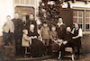
Familie Van den Muyzenberg-Kiessler
|
|
| |
This interactive map shows the geographic distribution of place names for people listed in the database. Different demographic events (e.g. birth, marriage, death) and place types can be viewed either separately or in total by selecting items on the bottom menu.
- Map Options
- The heatmap options shows concentrations of events, while selecting clusters and pins shows actual locations. By zooming in you can see the distribution and actual locations in greater detail.
- Years
- You can view places across all years, places that have no year information, or places within a selectable range of years. The time period can be changed via the forward and back buttons on the time-line beneath the map.
- Place List
- This displays the list of place names currently located on the map. The list can be ordered alphabetically either by the smallest locality name (i.e., town name, the county, etc.) or by the largest locality name (i.e., country, then state, etc.). This display can also be disabled to view a larger portion of the map.
- Pins
- Clicking on a map pin or on a place name in the adjacent place list will generate an information box that summarizes the numbers of demographic events in that place. Clicking on the place name in that information box will open a page that provides place information and a list of events and individuals from that place.
Happy exploring!
Map
|
|
|
|


